
GPS Navigation and Approaches
What amazing experiences night flying brings!
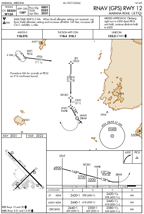
Took off just after sunset again last night for a quick trip down to Marana to practice GPS navigation along victor airways and then setup for a GPS approach and landing. With GPS navigation its really all about the pre-flight planning and setup the GPS instruments in the plane to track the GPS waypoints along the route and then loading up from the GPS system, the corresponding approach. Once loaded, the GPS guides us from point to point and after reviewing the approach plate (see below) we follow the approved decent altitude step downs to reach our minimum descent altitude (MDA) [418 ft] at which if we have enough visual cues of the runway, we can proceed to land. If however, we got down to the MDA and could not adequately see the runway, we would then go full power and climb to a holding position and decide if we wanted to wait it out or carry on to another airport. Last night because we were only simulating instrument conditions, we safely landed turned around and setup for our departure.
On the return flight, we flew over to Coolidge and shot (tried) another GPS approach, this time, using the prescribed approach procedure, flying to a given way-point and then looping back ground and descending on the approved step-downs. This time however, we pretended that we could not see the runway, so upon reaching our MDA, I crammed full power and overflew the runway heading up to the missed approach point.
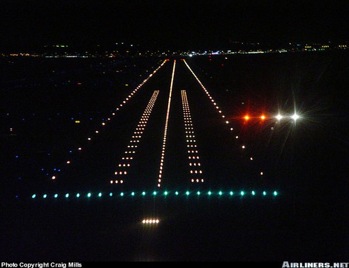
With only about a 15 min flight from Coolidge to Gateway, we had to quickly review our last GPS approach plate and brief the landing while quickly approaching the runway. Landing at Gateway at night is a real visual treat with all the runway and taxiway lighting clearly outlining the airport. Gateway also has a very helpful Precision Approach Path Indicator lighting system that’s an invaluable aid to night landings. After descending to our minimums at 420 ft, we then proceed visually using the PAPI lights that show us our glideslope down to the runway. Two red and two white lights means we are on track and four reds means we are too low. Following only these lights, we quickly descend to the runway surface and about 20 ft above, our landing lights finally illuminate the runway surface and we touch down perfectly on our spot.
Before starting instrument training I really had no idea how it all worked, but I have quickly come to realize what an amazing mix of technologies and procedures it is to safely guide airplanes large and small in low visibility conditions – which night flying technically is. However, that said, last night’s flight was probably the most stressful flight I have had in a very long time as the workload during instrument approaches is incredible high and with short flights between airports, there really is no breaks. The good news is that I will have several more flights to hone these skills and to get comfortable with the workload.
Marana (KAVQ) GPS -12 Approach Plate
PAPI (Precision Approach Path Indicator) Lights
PAPI Lights Video
Recent Comments